


Like the rest of the world, the agriculture industry is being transformed by technology. Digital agriculture promises growers increased production and savings on input cost while delivering more sustainable farming.
To help deliver on this lofty potential, Planet's supplies daily, high resolution satellite imagery to help analyse crop health and drive value for growers.
We're proud of our imagery, but we also know imagery doesn't drive innovation alone. Some of the leading agriculture companies and organisations across the globe draw on Planet data to help their customers make more informed decisions in the field.
Growers and the companies that serve them trust Planet's high-cadence, science-grade data. If you watch our On-Demand webinar (https://bit.ly/3ic1B5o) you can learn from insights on how frequent satellite imagery is fueling precision agriculture practices at every stage of the crop cycle, including planning, seeding and early-season operations, crop health and crop management and harvesting and yield optimisation.
Start the season strongly with satellite data
By: Planet's Steve Levay
As the new growing season opens, growers are looking to put the uncertainties of 2020 behind them and start fresh.
Digital technologies and the increasing availability of data from the field help provide a fresh perspective on where to focus resources and ensure a strong start for the year.
But where growers' equipment data isn't available or reliable, remote sensing data from satellite imagery is a scalable way to help with planning and early season operations.
Growers can analyse multiple years of data to understand crop yield trends or build management zones based on analysis of cover crops.
Planet's reliable, high-frequency satellite imagery offers broad area field coverage and dense time-series of field data to track productivity, providing the grower a range of insights to help them prepare for the season ahead.
How productive are my fields?
Vegetation indices calculated from near-daily PlanetScope imagery show where crop productivity is highest and lowest, as well as establish baselines for in-field variation.
Dense, year-over-year satellite data can also highlight topography and soil properties over broad areas, enabling growers to direct resources across vast field areas with greater reliability.
Accurate crop productivity data begets better definition of management zones and specific crop-yield forecasting. PlanetScope data can be used to understand cover crop biomass, producing accurate management zones to help growers test soil, optimise inputs (such as water, fertiliser, herbicides, etc.), save costs, and avoid overapplication.
What type and quantity of inputs are needed?
With data on yield performance, growers can translate their productivity into variable rate prescriptions that optimise inputs. Fine-tuned variable rate prescriptions will generate higher return on investment by planting the right amount of seed in the right place.
PlanetScope's daily coverage means you have a reliable source of data everywhere your customers grow, and enough data to generate prescriptions for fungicide or fertilizers once the season is underway.
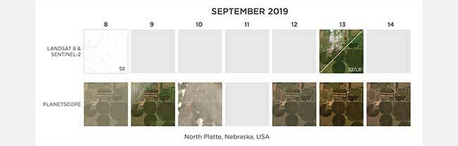
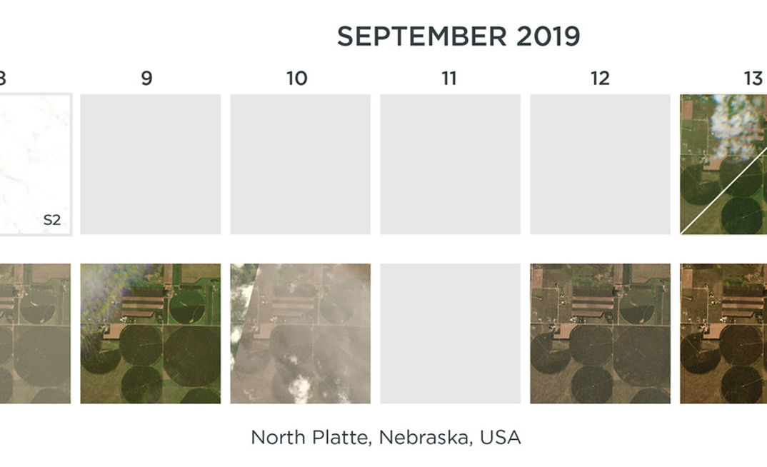
Available imagery by day from Landsat 8, Sentinel-2, and PlanetScope over North Platte, Nebraska
Top five misconceptions about satellite imagery for agriculture
From the early days of Landsat to present-day commercial providers, agriculture has been one of the largest adopters of satellite imagery. By partnering with leading agricultural companies over the years, we've gained a window into the day-to-day challenges, concerns, and opportunities that growers have across the globe.
Planet's vision is to deliver precise and reliable field-level crop information to help agriculture companies and their growers optimize inputs, monitor crop health, and improve yield.
We've gathered the top misconceptions about using satellite imagery for agriculture.
1. My customers don't trust results from satellite data.
We find the opposite. In addition to sending out people into the field to gather information, satellite data and insights can actually increase trust and help identify problems in the field. Our customers build vegetative indices that visualise crop health and then deploy that data to their growers and agronomists.
In many instances, a phone or tablet app helps spot water stress or disease, efficiently directing attention to locations in the field. Others build out reporting mechanisms that even email a list of areas for inspection.
2. My customers won't be able to do anything with imagery, they want answers.
A satellite image is more than meets the eye. By combining data from different portions of the electromagnetic spectrum, satellite data can be used to assess crop vitality with indices like the Normalized Difference Vegetative Index (NDVI), which shows whether plants are under stress, and what lifecycle stage a crop is in.
Planet customers such as Granular use our APIs to generate analytic visualisations that they integrate into their digital platforms, helping farmers optimise their inputs like fertilizers and stay on top of threats to their crops.
3. We only need a few images over the growing season.
For some agricultural use cases, a few images during the growing season can provide base level information on crop health but not nearly enough to really take the best action.
Some crops present relatively narrow time windows for action specific to key growth stages. Having a reliable source of up-to-date imagery from our daily monitoring ultimately provides a higher likelihood of getting usable data, especially when the risk of weather events like clouds can impact data continuity.
4. Drones are the best solution for insights. Satellites are too coarse in spatial resolution to tell me anything.
Drones are great. They deliver higher resolution imagery over fields and are capable of delivering detailed insights to growers. But drones are expensive to fly and they can only cover so much ground. Plus, you have to know where you want to fly ahead of time and schedule that flight.
With satellite imagery, you may trade spatial resolution for coverage, but when you need to deliver reliable cost-effective insights at scale, there's really no alternative.
While some satellite imagery may be too fuzzy to discern useful insights, PlanetScope's medium (3.7 m) spatial resolution is ideal for discerning fine details, even in smaller-scale farming operations. And PlanetScope's satellites are always on.
There's no need to task them ahead of time. They deliver coverage of every acre on earth.
5. Public data is good enough, and commercial satellite data isn't cost-effective.
Public Earth observation data from missions like Landsat and Sentinel can provide a ton of valuable information to scientists, researchers, and analysts.
It's free data, but getting insight from that ‘data' is not. There are significant, time-consuming and expensive challenges involved in getting pipelines in place to transform public imagery into clean, processed data, and this can be a huge burden on customers and end users.
Planet's modern, cloud-first APIs help process, stream, and deliver analysis-ready data at scale with the growth of your business.
With Planet, you can leverage the processing power of our platform to focus your expertise on your applications versus building your own imagery processing and cloud infrastructure.
Still weighing your options?
Visit us at planet.com/ag to learn more about innovative applications of satellite imagery in agriculture, and reach out to our team at sales@planet.com if you have questions.
ABOUT THIS COMPANY
Planet

Planet’s reliable, high-frequency satellite imagery offers broad area field coverage and dense time-series of field data.
HEAD OFFICE:
- 1 Raffles Place #18-61, 048616, Singapore
- Phone: 6597207307
- Website: planet.com/ag
- Email: sales@planet.com